At it’s heart the art of cartography is thousands of small decisions- about where to place labels, which features to label, which font and what size to use, or how to symbolize different types of geographic and cultural features. There are standards of course but there is so much room for expression within the standard.
When you make several of the same type of map the number of those decisions is drastically reduced and the process becomes less artistic and more formulaic. I still love the challenge of fitting all the information in the given space in the best way possible, but after a few years of doing that we were itching to get back to the creative side of cartography.
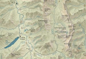
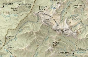
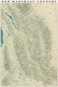
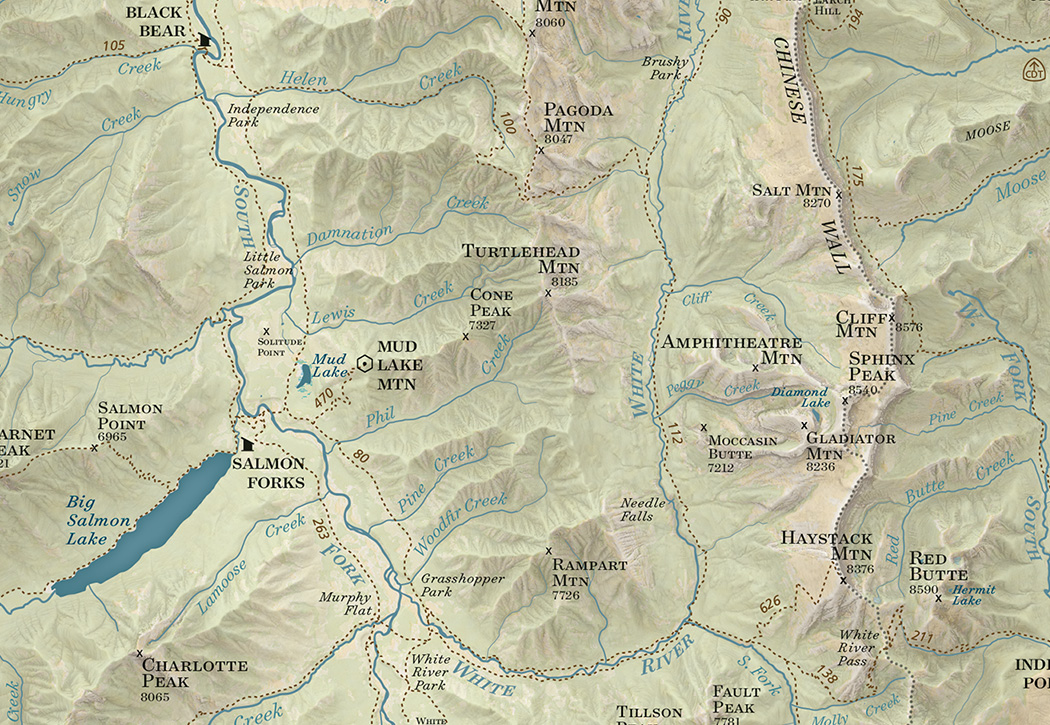
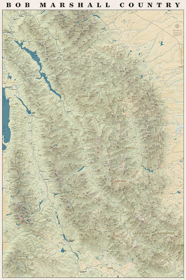
We have talked about (and received requests for) a map with the whole Bob Marshall Wilderness Complex since 2011 when we printed our first map. This spring the concept for that map finally started to take shape. We knew we wanted it to be totally functional so you could use it to daydream about new trips or reminisce about trips passed. We also wanted it to be an art piece- something that would look good in a frame on someone’s wall.
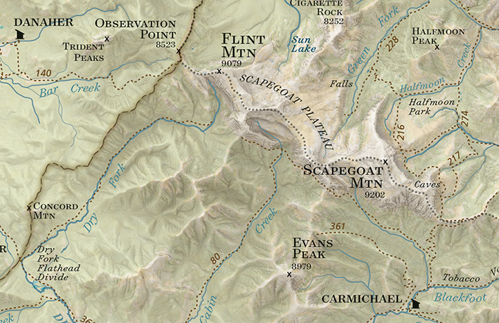
On the map you will find all the trails, cabins, trailheads, and ranger stations plus all the peaks, streams, rivers and geographic features that are on our other maps all overlaid on an updated terrain shading.
We are really pleased with how the map turned out and we had a lot of fun making it!
It also turns out when you put the entire Bob Marshall on one rectangular sheet of paper you end up with the entire Mission Range and Rattlesnake Wilderness on the page as well!
The whole map!
I had an inspiring conversation with Kevin at Rocky Mountain Map Gallery today about the Print vs Digital topic which has been on my mind a lot recently. It’s always fun to talk to someone who is as much, if not more of a map geek as I am. Our conversation followed several tangents but we kept arcing back to two main points.
1. Nothing can replace a print map
2. You don’t have to choose between print and digital, they should be used together
Some of the reasons we kept coming back to:
Planning. Especially when you are going somewhere you’ve never been before you can spread out maps on the table or (my personal preference) the floor and see the area you are planning to go in context. You notice how the mountain ranges and rivers fit together and how the trail network connects one valley to the next or how one trailhead is easily linked to another to create a more interesting loop.
Dreaming. People tell me all the time that they “love maps.” I do too. I think what they mean is that, like me, they can spend hours staring at a map noticing which peaks divide which drainages and which creeks form the headwaters for bigger rivers. You can’t get lost like that on a four inch (or twenty-four inch) screen. This blog post talks about scheming and dreaming to connect various trails that you might not have thought to connect before and the power of print to inspire new explorations of familiar places.
Maps tell stories. You can lay a map out on the table and it becomes an instant focal point of the conversation. You gather around it and trace your fingers along rivers and ridge lines and tell the story of your adventure. You can point out where you saw a bear or found a monster huckleberry patch or almost ran out of water. Zooming around google earth is fun but it isn’t the same.
Soul. A well-made print map is beautiful. Print is a much higher resolution than digital and misplaced labels or awkward line widths stick out much more when you can look at a map as a whole and not just a little piece at a time. It takes a lot of time and skill to fit data from all different sources together and make it look good. Cartographers spend hours agonizing over font sizes, label placement and color choices. In our case we spend weeks on the ground to GPS the trails as well. We know what the trail along a particular creek feels like underfoot. We know how the trail is just far enough from the creek that the creek’s name can be squeezed in between them on the map. We know the landscapes that our maps cover and we know our maps themselves intimately and I think it shows through in the final product.
Navigation. You can’t beat a GPS for ease of navigation. It is a wonderful thing to be able to look at a little screen and see exactly where you are. Especially for off trail navigation or for something like hunting where your focus might not be on your surroundings as you tromp through the woods it can be lifesaving to have a device to help navigate back to your camp.
That’s the thing: It’s not an either or choice. You don’t have to choose between a map and a GPS unit. They are both incredibly useful tools. Nothing beats a GPS for navigation or tracking. I use Strava and I love my GPS as much as the next person and I almost always have at least one GPS-enabled device with me when I’m running or hiking (and I frequently have two or three). But I would never leave my map behind- one of my favorite things is to unfold my map at the top of a peak and use it to pick out distant landmarks and understand the landscape around me and a GPS can’t do that.
“There are some good things to be said about walking. Not many, but some. Walking takes longer, for example, than any other known form of locomotion except crawling. Thus it stretches time and prolongs life. Life is already too short to waste on speed. I have a friend who’s always in a hurry; he never gets anywhere. Walking makes the world much bigger and thus more interesting. You have time to observe the details. The utopian technologists foresee a future for us in which distance is annihilated. … To be everywhere at once is to be nowhere forever, if you ask me.” –Edward Abbey
I spend a lot of time ruminating on this Edward Abbey quote when I’m on the trail. There’s something about the pace of walking that just feels “right.” My brain can easily keep up with processing the sights, sounds and smells around me when I’m not hurriedly trying to figure out where to put my feet or bike tire or ski.
In the age of the Go-pro walking at three miles and hour with fifty pounds on your back doesn’t seem very flashy, especially next to that video your friend posted of ripping down that crazy descent on a mountain bike. It’s humbling to spend an entire day putting one foot in front of the other and in the evening retrace my crooked path across the my current corner of the map but exhilarating to think I’ve made it that whole way under entirely my own power.
There is still a lot of snow up high but summer planning has begun and after an office-intensive spring I couldn’t be more excited to start walking again.