At it’s heart the art of cartography is thousands of small decisions- about where to place labels, which features to label, which font and what size to use, or how to symbolize different types of geographic and cultural features. There are standards of course but there is so much room for expression within the standard.
When you make several of the same type of map the number of those decisions is drastically reduced and the process becomes less artistic and more formulaic. I still love the challenge of fitting all the information in the given space in the best way possible, but after a few years of doing that we were itching to get back to the creative side of cartography.
We have talked about (and received requests for) a map with the whole Bob Marshall Wilderness Complex since 2011 when we printed our first map. This spring the concept for that map finally started to take shape. We knew we wanted it to be totally functional so you could use it to daydream about new trips or reminisce about trips passed. We also wanted it to be an art piece- something that would look good in a frame on someone’s wall.
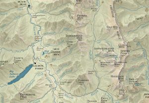
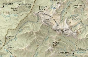
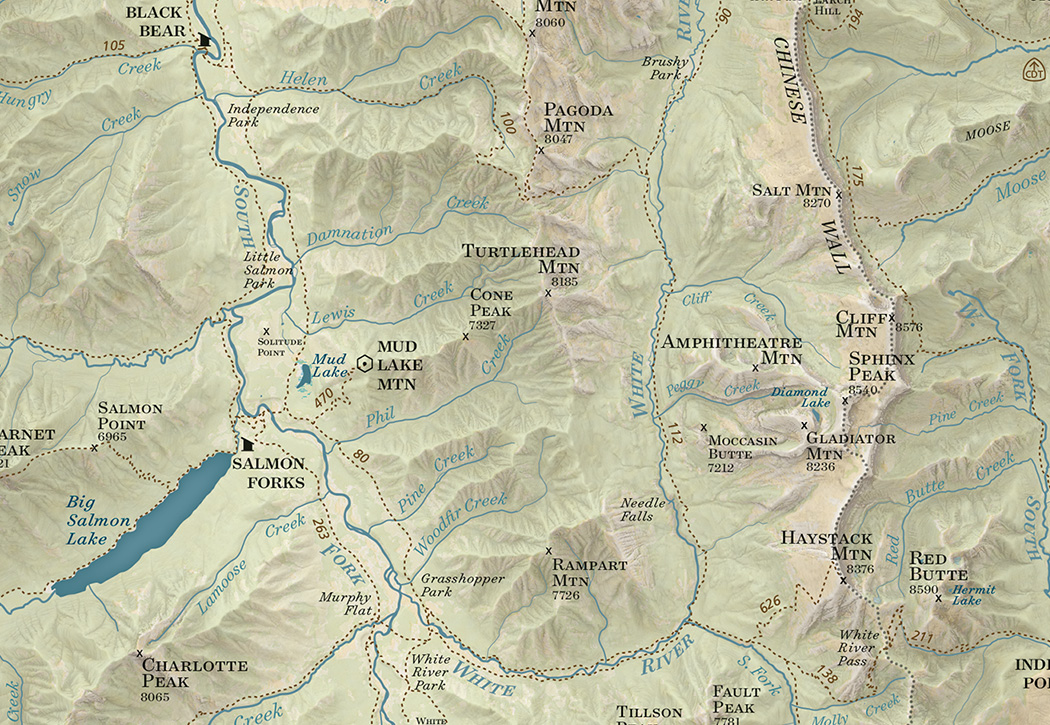
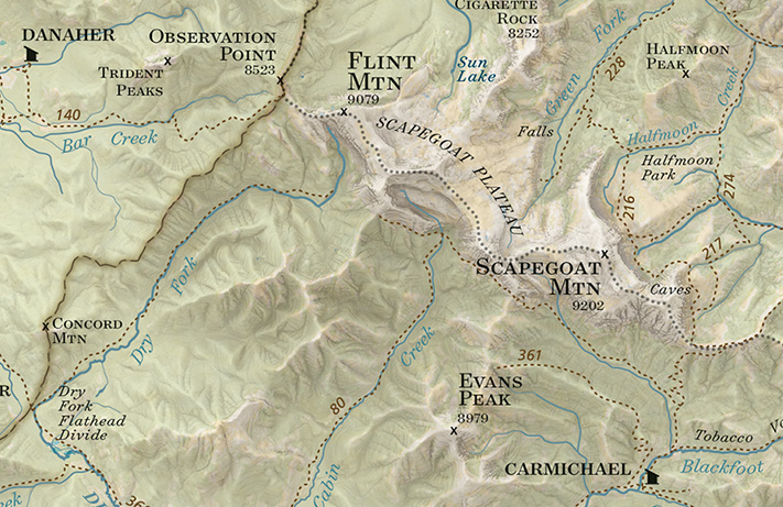
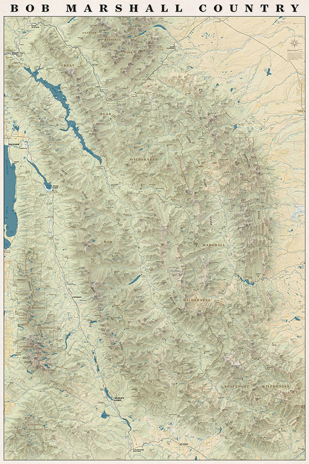
On the map you will find all the trails, cabins, trailheads, and ranger stations plus all the peaks, streams, rivers and geographic features that are on our other maps all overlaid on an updated terrain shading.
We are really pleased with how the map turned out and we had a lot of fun making it!
It also turns out when you put the entire Bob Marshall on one rectangular sheet of paper you end up with the entire Mission Range and Rattlesnake Wilderness on the page as well!
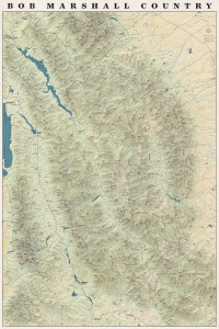
The whole map!
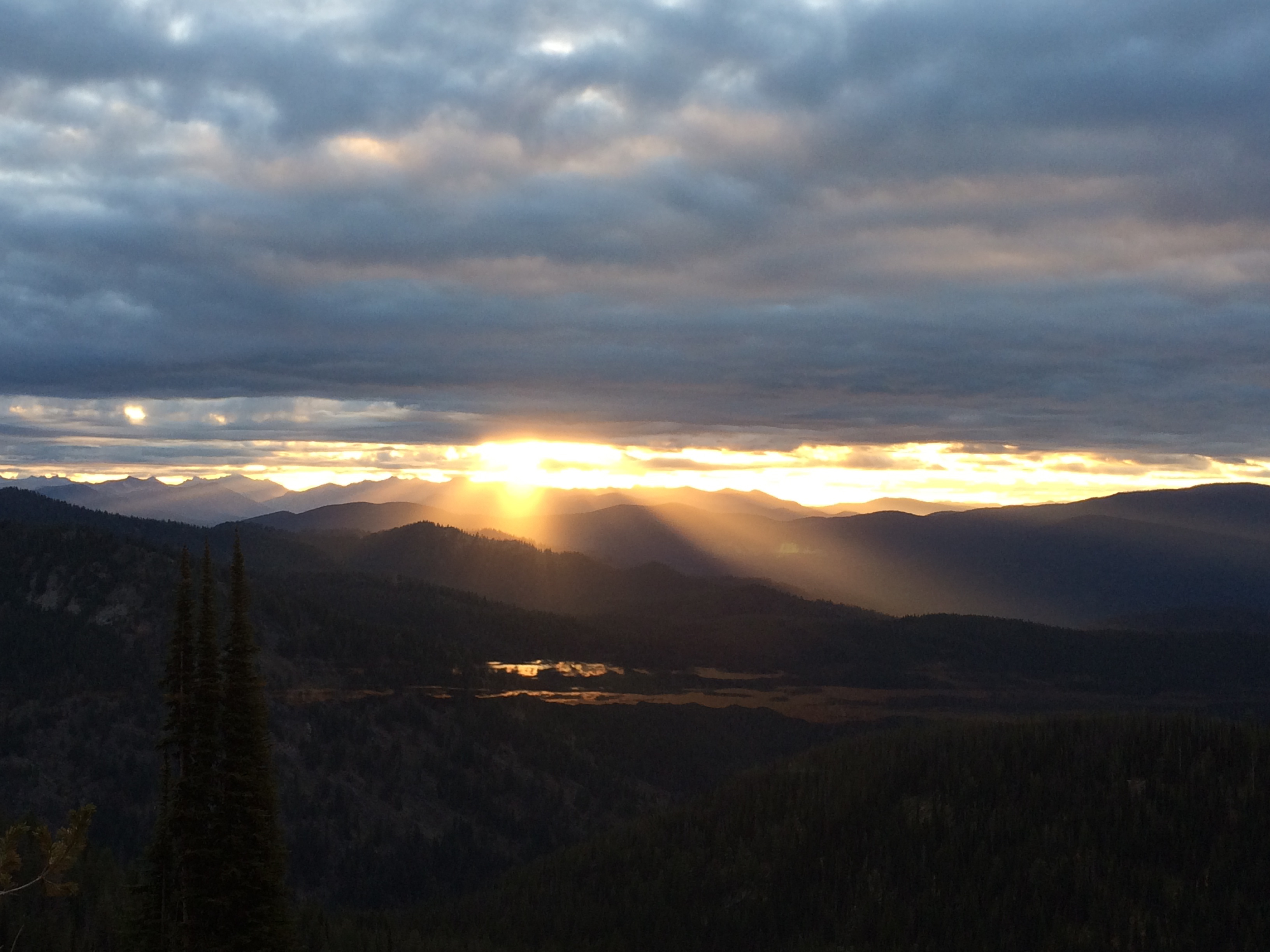
We spent September and October wrapping up our field season in the South Half of the Selway Bitterroot Wilderness. This is some beautiful, rugged and remote country! We got a little tired of the LONG drive from Missoula to get back to some of those trailheads (some took over seven hours to get to!) but we had a beautiful stretch of cooler weather which was much appreciated after a hot dusty summer.
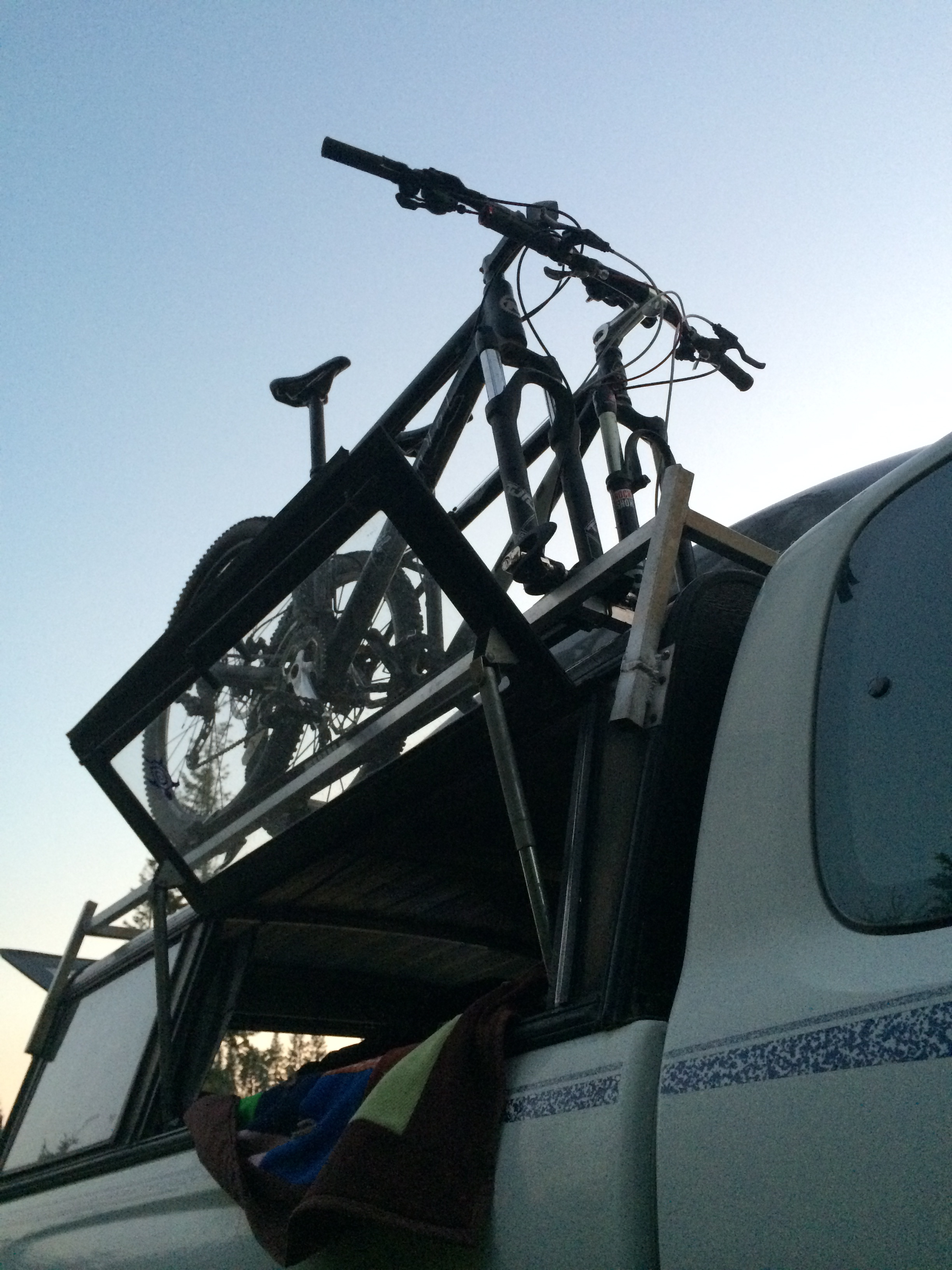
Sunrise over the Bitterroots from the Windy Saddle areaHome away from home, you never know what toys you might need
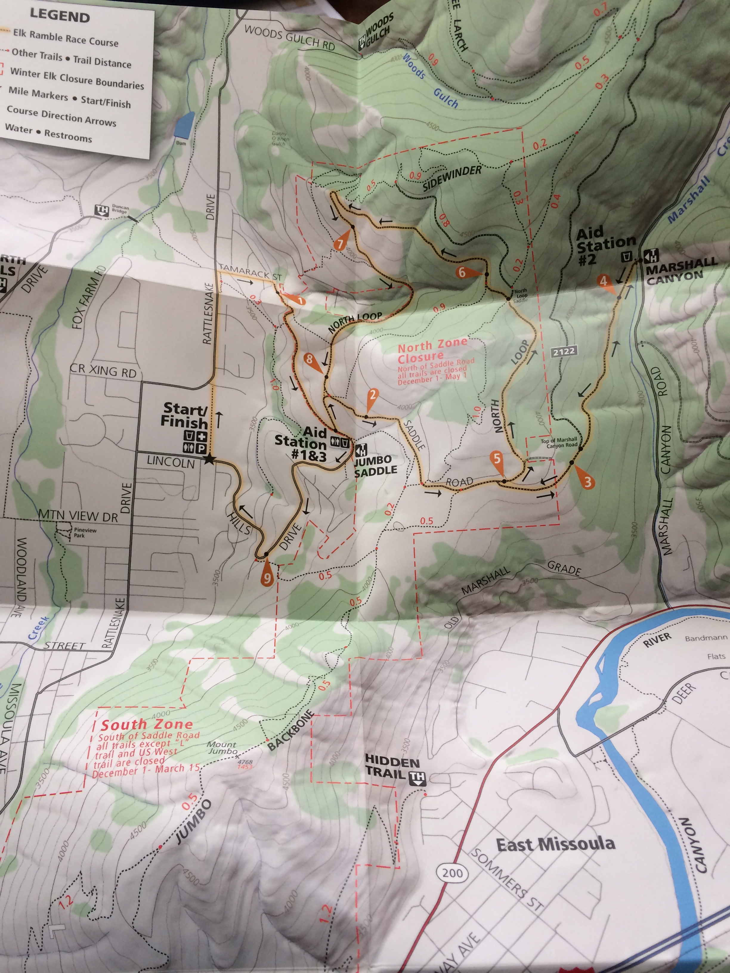
We got to catch up with the folks from the Selway Bitterroot Frank Church Foundation at the Telluride Mountain Film festival. Beautiful inspiring films and good company! We partnered with Run Wild Missoula to make a map of the Elk Ramble 15k trail race that took place on November 8th. Each participant received a map of the Mt Jumbo area with the race course highlighted printed on waterproof plastic. It was a super fun project and a really fun race!
Elk Ramble Map- crossing our fingers that this race can happen again!
We are deep into work on our next trail map- the South Half of the Selway Bitterroot Wilderness which we hope to print by next spring. It is always fun to re-live our summer on the trails as we comb through all the data.
“A wilderness, in contrast with those areas where man and his own works dominate the landscape, is hereby recognized as an area where the earth and its community of life are untrammeled by man, where man himself is a visitor who does not remain.” -The definition of Wilderness as stated in the 1964 Wilderness Act
I’ve spent most of the last two weeks visiting family and friends in the Northeast. Explaining what I do tends to be a little more involved in the Northeast because most people don’t have as thorough an understanding of federal land management as they do in the Rocky Mountain West. When I say I make maps of Wilderness areas I usually have to explain how a Wilderness area (capital “W”) is different than a National Park and usually contained within National Forest. The scale can be hard for people to wrap their heads around- some of the areas we are making maps of in Montana are bigger than the smaller New England states!
My explanation usually goes something like this: Wilderness is land within other public land that is set aside to remain “untrammeled.” The use of mechanized vehicles including bicycles is forbidden and the trails and infrastructure are maintained with traditional hand tools. In Montana most Wilderness areas are within National Forest Land and managed by the National Forests but they can also be managed by other agencies. Portions of many National Parks are managed as Wilderness but Wilderness areas are not managed like National Parks.
This week is the 50th anniversary of the Wilderness Act and all summer long events and articles have celebrated the anniversary. We are big proponents of any type of designation that protects wild places but our biggest loves are the huge Wilderness areas in western Montana. We are celebrating the anniversary of the Wilderness Act and the release of our newest map by offering 20% off all of our maps for this week only. So stock up!
I had an inspiring conversation with Kevin at Rocky Mountain Map Gallery today about the Print vs Digital topic which has been on my mind a lot recently. It’s always fun to talk to someone who is as much, if not more of a map geek as I am. Our conversation followed several tangents but we kept arcing back to two main points.
1. Nothing can replace a print map
2. You don’t have to choose between print and digital, they should be used together
Some of the reasons we kept coming back to:
Planning. Especially when you are going somewhere you’ve never been before you can spread out maps on the table or (my personal preference) the floor and see the area you are planning to go in context. You notice how the mountain ranges and rivers fit together and how the trail network connects one valley to the next or how one trailhead is easily linked to another to create a more interesting loop.
Dreaming. People tell me all the time that they “love maps.” I do too. I think what they mean is that, like me, they can spend hours staring at a map noticing which peaks divide which drainages and which creeks form the headwaters for bigger rivers. You can’t get lost like that on a four inch (or twenty-four inch) screen. This blog post talks about scheming and dreaming to connect various trails that you might not have thought to connect before and the power of print to inspire new explorations of familiar places.
Maps tell stories. You can lay a map out on the table and it becomes an instant focal point of the conversation. You gather around it and trace your fingers along rivers and ridge lines and tell the story of your adventure. You can point out where you saw a bear or found a monster huckleberry patch or almost ran out of water. Zooming around google earth is fun but it isn’t the same.
Soul. A well-made print map is beautiful. Print is a much higher resolution than digital and misplaced labels or awkward line widths stick out much more when you can look at a map as a whole and not just a little piece at a time. It takes a lot of time and skill to fit data from all different sources together and make it look good. Cartographers spend hours agonizing over font sizes, label placement and color choices. In our case we spend weeks on the ground to GPS the trails as well. We know what the trail along a particular creek feels like underfoot. We know how the trail is just far enough from the creek that the creek’s name can be squeezed in between them on the map. We know the landscapes that our maps cover and we know our maps themselves intimately and I think it shows through in the final product.
Navigation. You can’t beat a GPS for ease of navigation. It is a wonderful thing to be able to look at a little screen and see exactly where you are. Especially for off trail navigation or for something like hunting where your focus might not be on your surroundings as you tromp through the woods it can be lifesaving to have a device to help navigate back to your camp.
That’s the thing: It’s not an either or choice. You don’t have to choose between a map and a GPS unit. They are both incredibly useful tools. Nothing beats a GPS for navigation or tracking. I use Strava and I love my GPS as much as the next person and I almost always have at least one GPS-enabled device with me when I’m running or hiking (and I frequently have two or three). But I would never leave my map behind- one of my favorite things is to unfold my map at the top of a peak and use it to pick out distant landmarks and understand the landscape around me and a GPS can’t do that.
I can’t write an announcement about the Missions map without talking about our dear friend Kyra Jean Wiliams. Last spring when we first pulled the whole map together Kyra was probably the only person more excited about it than me. She was living in Saint Ignatius at the base of the Mission Range and spent much of her free time exploring the mountains out her back door. She called or stopped by almost every weekend to check on the progress of the map or to look at our draft to plan her weekend outing. As some of you may know Kyra passed away in a car accident last August. This map is dedicated to her and to the spirit of adventure and the willingness to forge her own path that she embodied.
Kyra and I went to college together in Maine and we both ended up in Missoula after we graduated. Kyra was one of those people I always wanted to see more of. She was so vibrant and such a kind and colorful spirit. So grounded and so at peace with who she was and what she knew to be important in life. Unlike most of my female friends we didn’t spend a lot of time talking about relationship drama or life in a broad metaphorical terms. We talked about business plans and ways to create fulfilling careers doing what we loved in a way that we could avoid burning out. We talked about our Bates peers who were living in bigger cities following more traditional paths and how we felt drawn to this mountain town where you can touch the wilderness with one hand and gourmet coffee with the other. We both fell in love with Missoula because the culture here encourages a certain kind of dreaming- about how life doesn’t have to be either a successful career climbing the ladder or full of adventure; it’s possible to have both at the same time. It was always such a comfort to talk with someone who came from the same background and could appreciate differences between Missoula and Bates from the same perspective as me. I miss her dearly and I continue to be inspired by her passion for living life to the fullest.
-Amelia
Kyra in her little home at the base of the Missions photo credit: Grant Haynes
Have you been using our South Half of the Bob Marshall map? We’re getting ready to print a second edition and we want to hear from you. Have you found any mistakes? We’re looking for anything from mis-named peaks or trails to spelling errors. Shoot us an email at info@cairncarto.com and let us know!
It’s an exciting day here at Cairn Cartographics. We’re proud to announce that our two new maps are printed, just in time for summer.
Printing the North Half of the Bob Marshall Wilderness complex map is the culmination of a project that has taken us close to three years. You wouldn’t be the first one if you told us that was an awfully big project to tackle as our first map. I won’t say there haven’t been moments when I’ve wondered if maybe we should have started with something smaller but over a thousand miles of walking and a fair amount of blood sweat and tears later I couldn’t be more proud.
I’m so excited about this new map of the Rattlesnake. Like a lot of people here I’m a transplant to Missoula and this map is pretty much the reason I’ve chosen to call this home. We are so lucky with our access to recreation- there are awesome trails in every direction that you can access right from town, there’s the Rattlesnake Wilderness which always surprises me with how rugged it is, there’s the Blackfoot and Clark Fork Rivers. The crazy thing is, until now there wasn’t a map with the wilderness, national recreation areas, and city open-space all on one page. This is the map I’ve wanted to own since I moved here and I hope it will inspire people to take advantage of this beautiful place we live and explore some new trails. See you out there-
This winter was built up to be another La Niña year which translates to another winter like last year. Tons of snow and hardly a glimpse of the sun between November and March. However, it’s mid December and ski areas are barely open and we’ve yet to have a sub-zero cold snap. Not that I’m complaining, it’s not even officially winter yet and I’ve been loving the uncharacteristic sunny days we’ve been having.
Smells like vanilla
I took advantage of some of the sun last week to take my camera and the GPS for a walk.
looking back to town from Blue Mountain
It’s been really fun finishing up the GPS work for our upcoming Missoula map. It’s been a good motivator to branch out from my old favorites and explore some new trails.
Cool patterns in the ice by the Tower St trails
I used to be one of those people who ran or hiked with a basic watch and nothing else- not even an ipod. Now I regularly carry three different GPS devices plus maps with notes scribbled all over them. Not because I’m worried about getting lost or really concerned about my fitness. I’m just trying to figure out how to make the most accurate maps. And I still get lost sometimes.
Thankful for all our backers on Kickstarter. Our map wouldn’t be in stores today without all of you.
Thankful for all the wild places on this planet and the people who had the forethought to preserve them.
A wild place
Thankful for health and strong legs that carry me up and over mountains.
Thankful to live in a place where mountains rather than skyscrapers fill the view out my window and where the trails leading out of town are too many to count.
thankful to live in a place where I can walk places like this out my front door
Thankful for all the family and friends who have encouraged and supported us as our dream of making maps becomes a reality.
Thankful for seasons because hot summer days allow me to appreciate winter and long winter nights have me dreaming of endless summer sun but really I could never live without both.
changing seasons
And most of all thankful for the best co-worker/tent mate/tech-support/fixer-of-all-things-broken a girl could ask for.
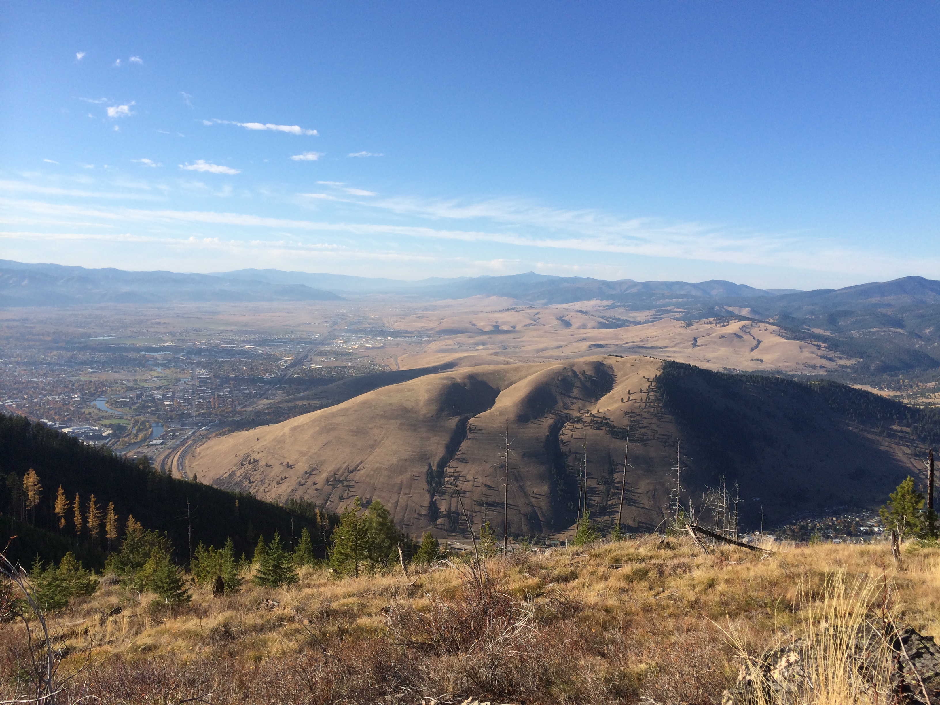
View from Stewart Peak, Missoula's down there in the smoke
I read a lot more in the summer. Long evenings in the tent lend themselves to getting lost in a book much more than evenings working on a map in front of a computer. Last night I finally finished Norman Maclean’s Young men and Fire. I started it while there were still several fires going strong around here which must have inspired me to pull it off the shelf. The fires have died down now (thank goodness) but I’ve been thinking a lot about them and their influence on the landscape here.
If you haven’t read it, Young Men and Fire is a detailed account of the Mann Gulch Fire, which burned about twenty-five miles outside of Helena in 1949. Thirteen people died in the fire, twelve smoke jumpers and the ranger who met them on the ground. Only three smoke jumpers survived. Maclean saw the aftermath of the fire firsthand which must have planted the seed that lead him to return to study the fire in detail decades later. He spent several years piecing together the events and decisions that led to the fire fighter’s deaths. The book, found in Maclean’s desk and published after his death, is a compilation of his conversations with the survivors and countless visits to the scene of the fire as well as research into the science and mathematics of wild fires.
In addition to being an explanation of the tragedy at Mann Gulch, the book is an account of Maclean coming to terms with old age. Researching the fire was the project that kept Maclean busy in the last years of his life. He writes about how the mental challenge of understanding the technical aspects of fires, as well as the physical challenge of getting to and hiking around Mann Gulch kept him strong and engaged.
evening light on burned trees
I think most people, especially those unfamiliar with wild fire find a post-burn landscape overwhelming. Silvery dead trees as far as you can see distract from the continuity of a green landscape. When Jamie and I were working in Yellowstone one friend of a friend described the park, post-1988 fires as “hell on earth.” Unlike most processes that shape the landscape, fire’s effects are immediately visible, measured in overnight transformations rather than centuries of imperceptible change. To me the post-fire landscape is much easier to look at on a macro scale. The patterns revealed in silvery wood, the flowers or the the curling of smaller branches into spirals. When I turn my eyes to detail, I’m less overwhelmed by the big picture.
Big Salmon and Hammer Creek Fires getting big
There were several fires in the Bob Marshall and around Missoula this past summer. One afternoon in August while Jamie and I ate lunch on top of Green Mountain we noticed a couple wisps of smoke drifting up towards the clouds over near the South Fork. We didn’t think much of it and headed down. About an hour later we came around the ridge to head down Trail Creek and the wisps had turned into giant mushrooming pillars of smoke towering over the landscape. Those were the initial runs of the Hammer Creek and the Big Salmon Fires which burned over eleven thousand acres in August and September.
I hadn’t read a book by Norman Maclean since my freshmen year of college when the “west” was still a conceptual landscape to me. Even after five summers in Montana I still think about wild fire in the abstract; big clouds on the horizon and hazy mornings in the valleys. Reading Young Men and Fire in the context of the landscape where it takes place was an entirely different experience from that introductory literature class. I’m still relatively new to a fire-shaped ecosystem and Young Men and Fire made fires a little more real for me and taught me a lot about what’s happening underneath those big mushroom clouds.