At it’s heart the art of cartography is thousands of small decisions- about where to place labels, which features to label, which font and what size to use, or how to symbolize different types of geographic and cultural features. There are standards of course but there is so much room for expression within the standard.
When you make several of the same type of map the number of those decisions is drastically reduced and the process becomes less artistic and more formulaic. I still love the challenge of fitting all the information in the given space in the best way possible, but after a few years of doing that we were itching to get back to the creative side of cartography.
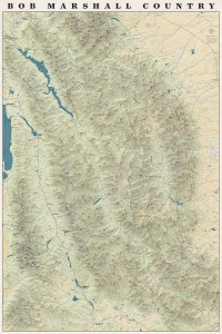
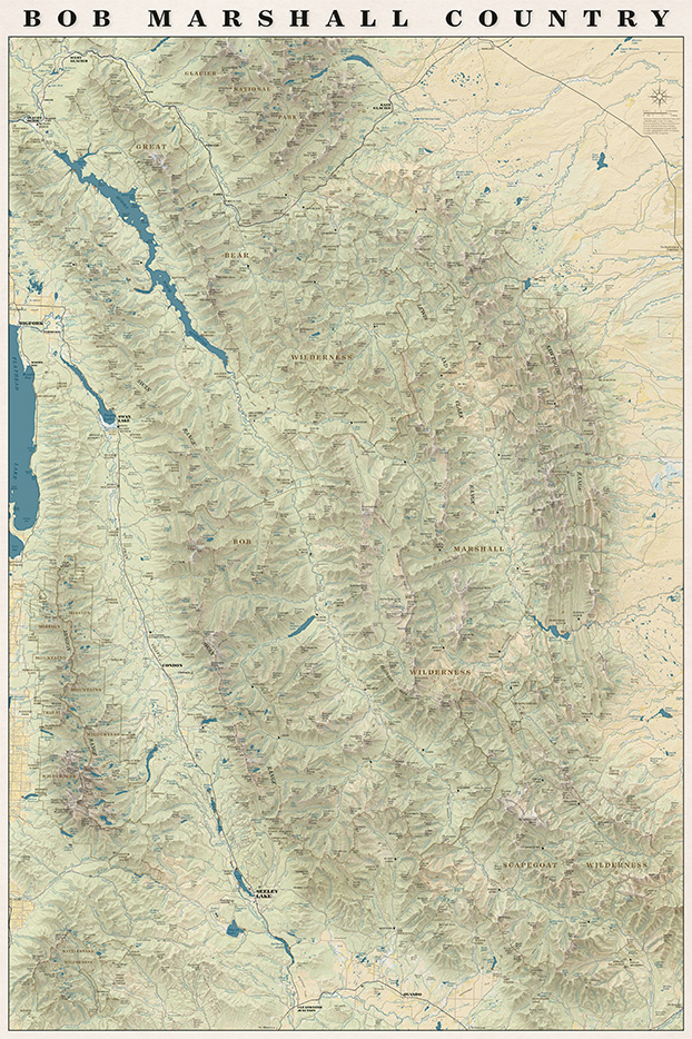
We have talked about (and received requests for) a map with the whole Bob Marshall Wilderness Complex since 2011 when we printed our first map. This spring the concept for that map finally started to take shape. We knew we wanted it to be totally functional so you could use it to daydream about new trips or reminisce about trips passed. We also wanted it to be an art piece- something that would look good in a frame on someone’s wall.
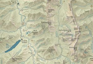
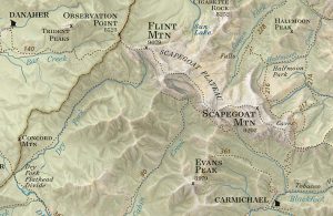
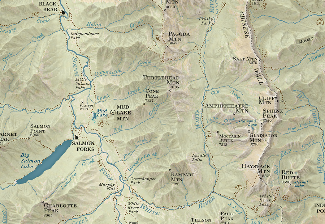
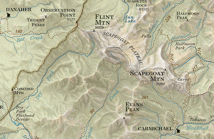
On the map you will find all the trails, cabins, trailheads, and ranger stations plus all the peaks, streams, rivers and geographic features that are on our other maps all overlaid on an updated terrain shading.
We are really pleased with how the map turned out and we had a lot of fun making it!
It also turns out when you put the entire Bob Marshall on one rectangular sheet of paper you end up with the entire Mission Range and Rattlesnake Wilderness on the page as well!
The whole map!
Every spring since 2011 it has been our goal to have a map finished and printed and on its way to customers by April. Our track record hasn’t been very good though- we’ve printed in June, July and last year in September. This year we really buckled down and we went to press the last week in March and it feels so good to be writing this new map announcement before the high country trails have even started to dry out and folks are still planning summer adventures.
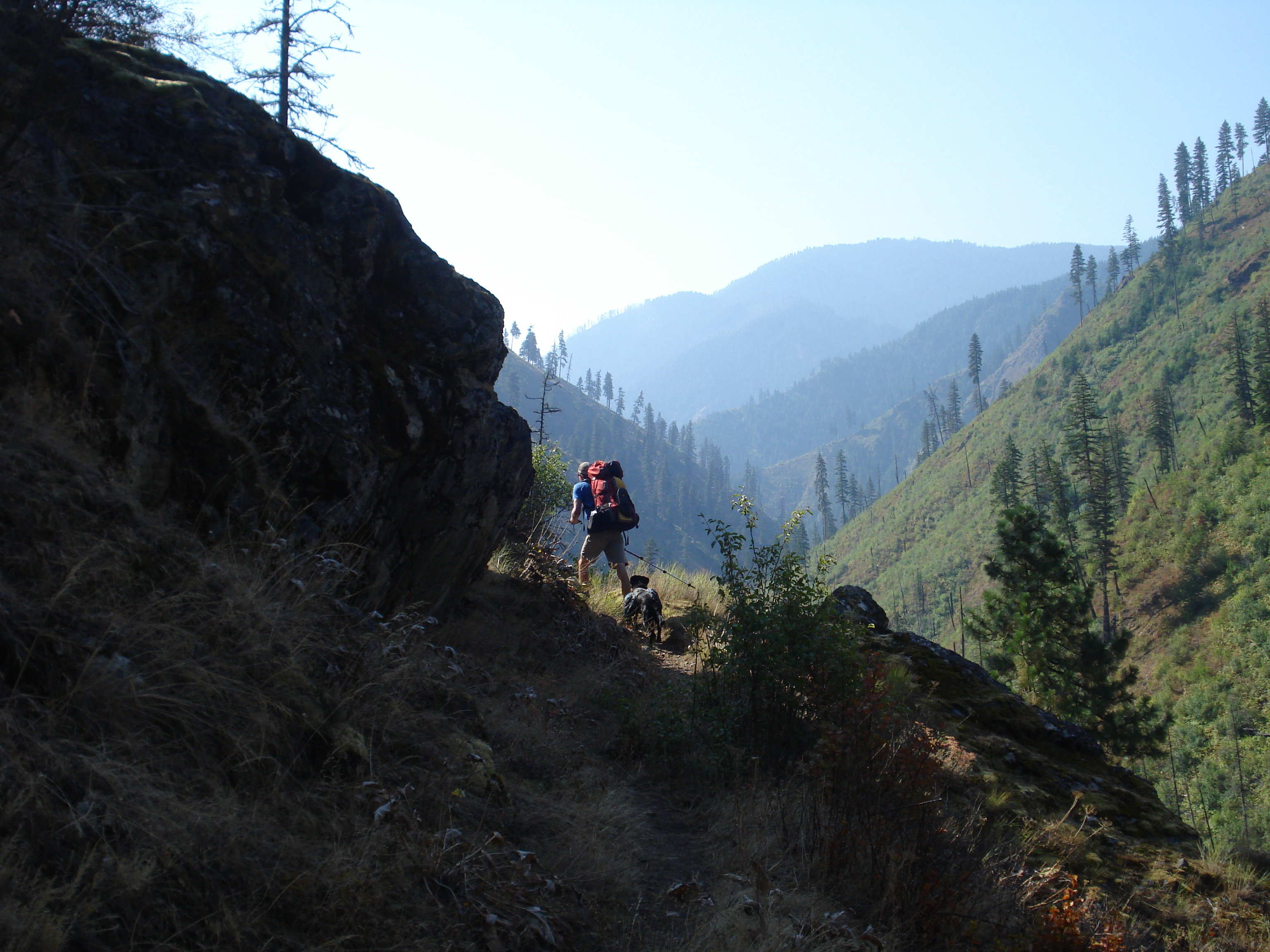
The South Half of the Selway Bitterroot surprised us with how remote it feels and how varied the terrain is. From the highest peaks in the Bitterroot Range to sandy beaches on the Selway River there is a little of everything. As the crow flies a lot of the terrain looks like it isn’t too far from the nearest road- but when that road is the Magruder corridor road, or even Highway 12 a nearby by road doesn’t necessarily mean close proximity to civilization. Highway 12 might be one of the few federal highways in the lower 48 where you can drive over 100 miles without cell service!
Below are some pictures of our favorite places from this map. You can order it now from our website or pick one up at your favorite outdoor retailer in western Montana.
Watchtower Creek was one of our favorite hikes of the whole summer- awesome scenery, TONS of huckleberries and a good trail
The Montana/Idaho divide trail follows the state line north and south of Nez Perce pass through some beautiful meadows and ridges
Piper relaxing after a swim at Glen Lake- a great hike for kids with spectacular views
Green Mountain Lookout has views into the Selway Bitterroot and Frank Church in all directions
Some meadows just off the Magruder Road near Poet Creek. This is a section of the old Nez Perce Indian Trail
The view toward the Bitterroots from Spot Mountain Lookout. It’s five thousand feet in about six miles from the road to Paradise up to this lookout and you can see wilderness in every direction from the top.
There are countless steep ridges above the Selway River, this is the view from the ridge above Paradise Guard station near the put-in for the wilderness float section of the Selway River
Piper and Jamie on the ridge above Paradise
Copper Butte near Indian Hill high above the Selway River. Grassy ridges for days
Near Buck Peak- we spent five days backpacking in this area and didn’t see a single other person
Fall camping at Buck Lake- we tend to avoid camping on lakes during the summer because of Mosquitos but in late September they are beautiful!
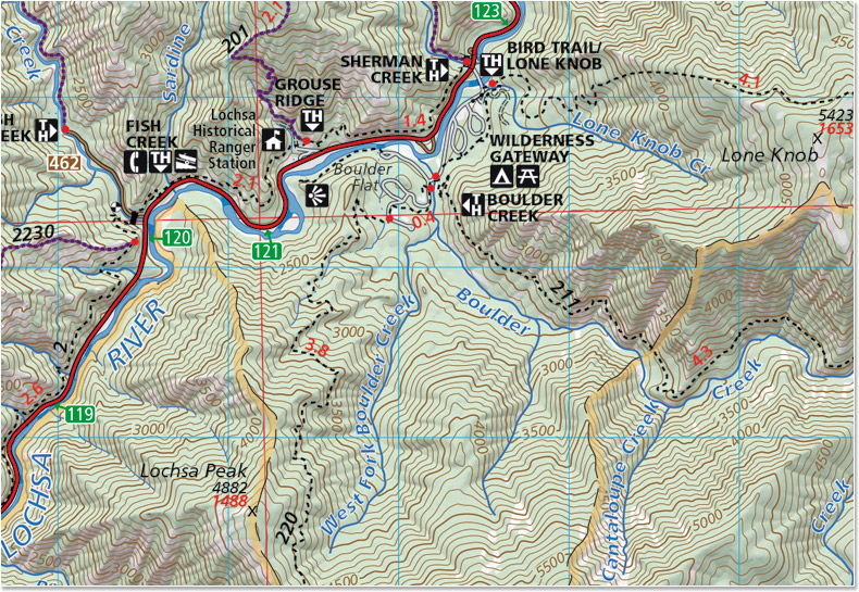
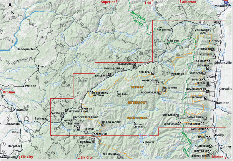
We are so excited to announce the release of our fifth map- The North Half of the Selway-Bitterroot Wilderness! This map straddles the Montana-Idaho border and covers well over half of the Selway Bitterroot Wilderness. This is a spectacular area and we had some amazing experiences while we were out gathering data for this map. Grab a copy and head out there!
Included on the map:
Highway 12 from Lolo, Montana to Lowell, Idaho
Highway 93 from Lolo, Montana to the Lost Horse Road
The Bitterroot Range from Lolo Peak South to the Twin Lakes Trailhead and the Lost Horse area
Bitterroot Canyons between Hamilton and Lolo Including Blodgett and Kootenai Creeks
The Selway Road from Highway 12 in Lowell to Race Creek Trailhead
The Selway River from the Confluence with the Clearwater upstream to Moose Creek
Moose Creek Ranger Station
Elk Summit area
Jerry Johnson, Stanley and Weir hot springs
Map SampleArea CoveredA hike down the Selway River trail #4 is not to be missed!
“There are some good things to be said about walking. Not many, but some. Walking takes longer, for example, than any other known form of locomotion except crawling. Thus it stretches time and prolongs life. Life is already too short to waste on speed. I have a friend who’s always in a hurry; he never gets anywhere. Walking makes the world much bigger and thus more interesting. You have time to observe the details. The utopian technologists foresee a future for us in which distance is annihilated. … To be everywhere at once is to be nowhere forever, if you ask me.” –Edward Abbey
I spend a lot of time ruminating on this Edward Abbey quote when I’m on the trail. There’s something about the pace of walking that just feels “right.” My brain can easily keep up with processing the sights, sounds and smells around me when I’m not hurriedly trying to figure out where to put my feet or bike tire or ski.
In the age of the Go-pro walking at three miles and hour with fifty pounds on your back doesn’t seem very flashy, especially next to that video your friend posted of ripping down that crazy descent on a mountain bike. It’s humbling to spend an entire day putting one foot in front of the other and in the evening retrace my crooked path across the my current corner of the map but exhilarating to think I’ve made it that whole way under entirely my own power.
There is still a lot of snow up high but summer planning has begun and after an office-intensive spring I couldn’t be more excited to start walking again.
The idea to make a map of the Missions started in the spring of 2012. We were wrapping up the final details on our maps of the North half of the Bob Marshall and the Rattlesnake. We were in the beginning stages of shopping for our first house. We had two big family vacations and a week-long river trip planned for the summer. We knew we wanted to tackle another big wilderness map but after two years of going full steam we needed to slow down a little. We decided on the Missions for several reasons: its proximity to Missoula, we could do almost all the hiking as day hikes and, after driving past the Missions several times a week for the two previous summers we wanted to stop and explore!
The hiking part of the Missions map went fairly smoothly- although we may not have said that at the time. We had some frustrating mornings trying to find trailheads and a few adventures trying to discern if we were on a “real” trail or not. But for the most part we hiked to a lot of beautiful lakes, found some choice car camping spots and we were able to be in town enough to buy a house and move into it.
Putting the map together was a different story. Like many small businesses in their first years of business we have experienced some growing pains in the last year. As the volume of work grows and we try to balance outside jobs with keeping our existing maps up to date something was bound to slip through the cracks. The Missions map, as many of you know, has been “almost done” since last April. The final touches on a map always take much longer than we think they will and so here we are in January finally making the announcement that the map is ready!
Publication timeline aside, we are so excited to get this map out into the world. The Mission Range is a spectacular place. It has a little of everything- from craggy peaks and alpine lakes to dark cedar forest to beautiful doug fir parks and some of the best huckleberry patches we have ever seen. And it’s all packed into one super-accessible skinny little range. Whether you are looking for a multi-day ski tour, a Sunday stroll to a lake with the kids or a big day of bagging peaks there’s something for everyone. As always itis available at retailers around western Montana and on our website.
We’ve turned the corner on summer, instead of feeling the luxury of extra time in longer days and open schedules stretching into the future, we’re looking September in the eye. We’re feeling the occasional hint of fall in a cool morning. There’s a reassessment happening, a taking stock of adventures planned and adventures had and a frantic planning to squeeze the remaining river trips, hikes and summer meals into the next few weeks. Maybe we feel this especially strongly in a college town where at times it feels like the whole city operates on a September-June school schedule.
Driving down some forest service roads the other day I was struck by how right now is the pinnacle of summer, that elusive point where foliage is full and green without a single hint of red or yellow. Orchards and gardens everywhere are bursting with the riches of late summer. Evenings are warm and lingering, days are hot and the hazy sky is buzzing with horseflies and mosquitos. As usual I feel like summer snuck through while I was looking the other way which is not necessarily a bad thing. The last few weeks have been full to the brim in a wonderful way- traveling to visit family, swimming in lakes after long hot days exploring a new mountain range, a few lazy afternoons on the river, some delicious summer meals with friends, and of course shipping out order after order of maps to wholesalers around Montana and customers across the country. I couldn’t really ask for more, but I’m still feeling the crunch to eat more corn on the cob and stand on top of some dramatic peaks and generally just soak up as much summer as I can before the days get noticeably shorter and life shifts into its fall schedule.