We are so excited to announce the release of our fifth map- The North Half of the Selway-Bitterroot Wilderness! This map straddles the Montana-Idaho border and covers well over half of the Selway Bitterroot Wilderness. This is a spectacular area and we had some amazing experiences while we were out gathering data for this map. Grab a copy and head out there!
Included on the map:
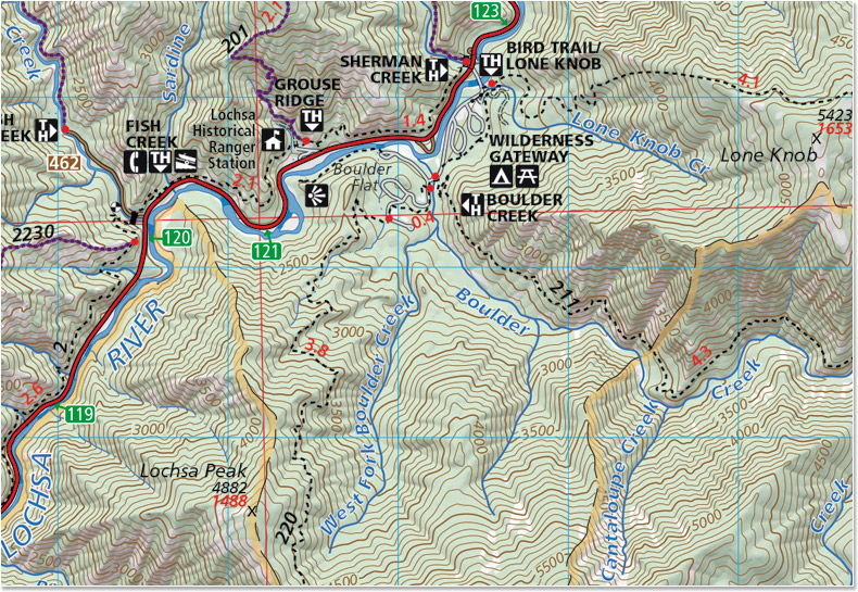
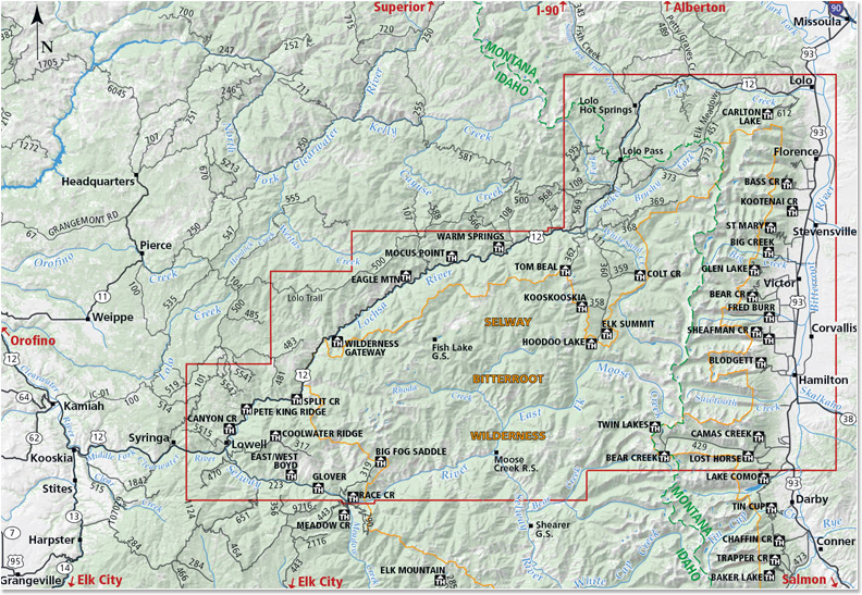
Highway 12 from Lolo, Montana to Lowell, Idaho
Highway 93 from Lolo, Montana to the Lost Horse Road
The Bitterroot Range from Lolo Peak South to the Twin Lakes Trailhead and the Lost Horse area
Bitterroot Canyons between Hamilton and Lolo Including Blodgett and Kootenai Creeks
The Selway Road from Highway 12 in Lowell to Race Creek Trailhead
The Selway River from the Confluence with the Clearwater upstream to Moose Creek
Moose Creek Ranger Station
Elk Summit area
Jerry Johnson, Stanley and Weir hot springs
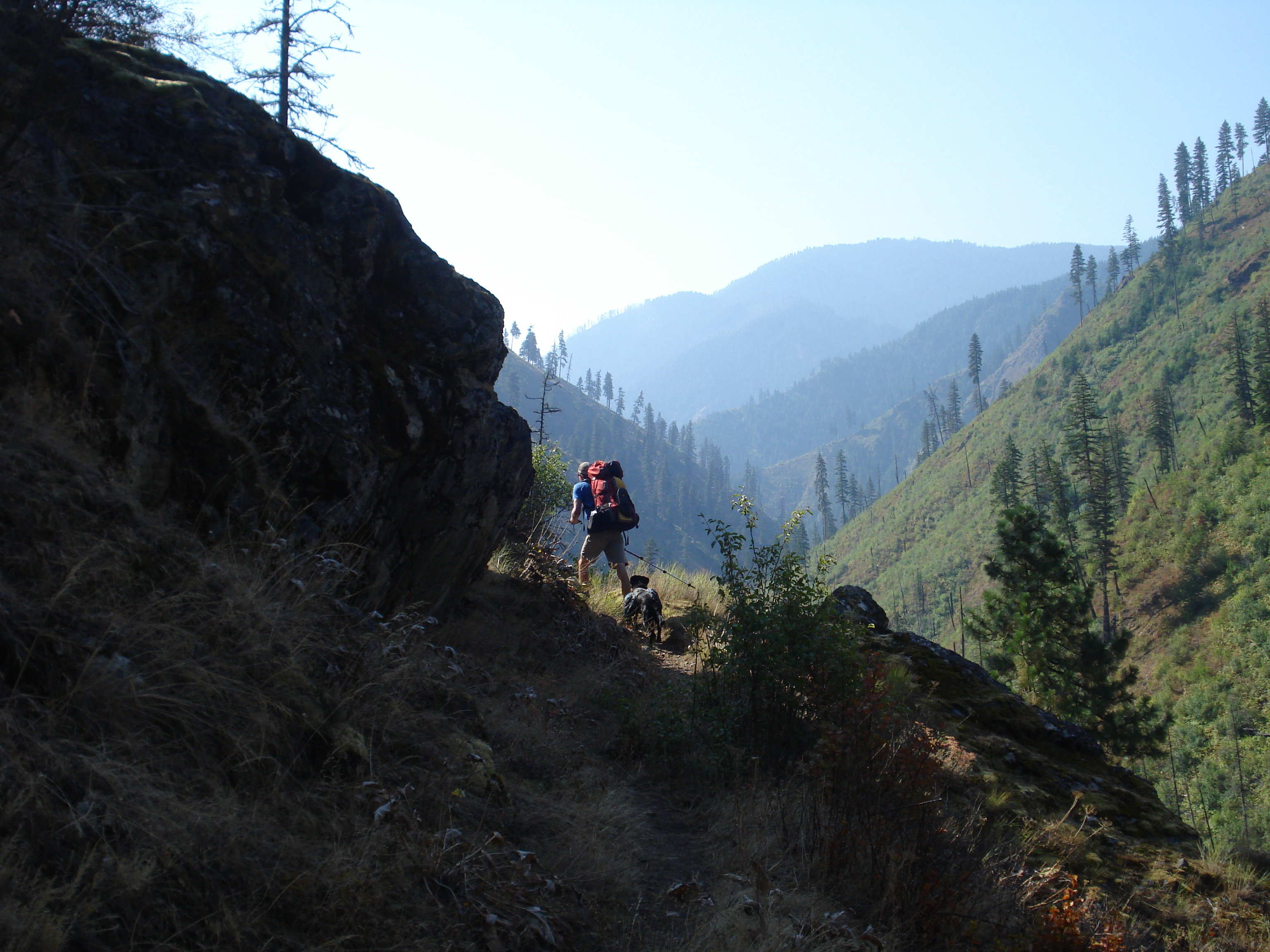
Map SampleArea CoveredA hike down the Selway River trail #4 is not to be missed!
I had an inspiring conversation with Kevin at Rocky Mountain Map Gallery today about the Print vs Digital topic which has been on my mind a lot recently. It’s always fun to talk to someone who is as much, if not more of a map geek as I am. Our conversation followed several tangents but we kept arcing back to two main points.
1. Nothing can replace a print map
2. You don’t have to choose between print and digital, they should be used together
Some of the reasons we kept coming back to:
Planning. Especially when you are going somewhere you’ve never been before you can spread out maps on the table or (my personal preference) the floor and see the area you are planning to go in context. You notice how the mountain ranges and rivers fit together and how the trail network connects one valley to the next or how one trailhead is easily linked to another to create a more interesting loop.
Dreaming. People tell me all the time that they “love maps.” I do too. I think what they mean is that, like me, they can spend hours staring at a map noticing which peaks divide which drainages and which creeks form the headwaters for bigger rivers. You can’t get lost like that on a four inch (or twenty-four inch) screen. This blog post talks about scheming and dreaming to connect various trails that you might not have thought to connect before and the power of print to inspire new explorations of familiar places.
Maps tell stories. You can lay a map out on the table and it becomes an instant focal point of the conversation. You gather around it and trace your fingers along rivers and ridge lines and tell the story of your adventure. You can point out where you saw a bear or found a monster huckleberry patch or almost ran out of water. Zooming around google earth is fun but it isn’t the same.
Soul. A well-made print map is beautiful. Print is a much higher resolution than digital and misplaced labels or awkward line widths stick out much more when you can look at a map as a whole and not just a little piece at a time. It takes a lot of time and skill to fit data from all different sources together and make it look good. Cartographers spend hours agonizing over font sizes, label placement and color choices. In our case we spend weeks on the ground to GPS the trails as well. We know what the trail along a particular creek feels like underfoot. We know how the trail is just far enough from the creek that the creek’s name can be squeezed in between them on the map. We know the landscapes that our maps cover and we know our maps themselves intimately and I think it shows through in the final product.
Navigation. You can’t beat a GPS for ease of navigation. It is a wonderful thing to be able to look at a little screen and see exactly where you are. Especially for off trail navigation or for something like hunting where your focus might not be on your surroundings as you tromp through the woods it can be lifesaving to have a device to help navigate back to your camp.
That’s the thing: It’s not an either or choice. You don’t have to choose between a map and a GPS unit. They are both incredibly useful tools. Nothing beats a GPS for navigation or tracking. I use Strava and I love my GPS as much as the next person and I almost always have at least one GPS-enabled device with me when I’m running or hiking (and I frequently have two or three). But I would never leave my map behind- one of my favorite things is to unfold my map at the top of a peak and use it to pick out distant landmarks and understand the landscape around me and a GPS can’t do that.
I joked last night that having a map that we made on TV is pretty dorky- it would be cool if one of us were actually on TV, or even our dog (we don’t have a dog, but if we did, that would probably be cooler than a map…)
But, we’re still excited that some maps we made will be featured in a Montana PBS special about Smoke Elser, an outfitter in the Bob Marshall Wilderness. I mean, it’s pretty exciting that the “Bob” is on TV to begin with, it’s just bonus that they used our maps! We made an overview map of western Montana and a close-up of the Danaher area. For those of you who have seen our map of the South Half of the “Bob,” the Danaher map will look familiar, we just made a couple changes to the map we published. It will air several times. Look for it Tonight at 7pm, Thursday 11/24 at 3pm, Tuesday 11/29 at 7:45pm, Thursday 12/29 at 7pm and Saturday 12/31 at 4:30pm
Now we just need to track down someone with a TV so we can watch it!
you can read more about the special here: http://www.montanapbs.org/3MilesAnHour/