At it’s heart the art of cartography is thousands of small decisions- about where to place labels, which features to label, which font and what size to use, or how to symbolize different types of geographic and cultural features. There are standards of course but there is so much room for expression within the standard.
When you make several of the same type of map the number of those decisions is drastically reduced and the process becomes less artistic and more formulaic. I still love the challenge of fitting all the information in the given space in the best way possible, but after a few years of doing that we were itching to get back to the creative side of cartography.
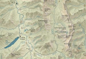
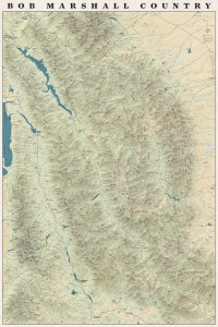
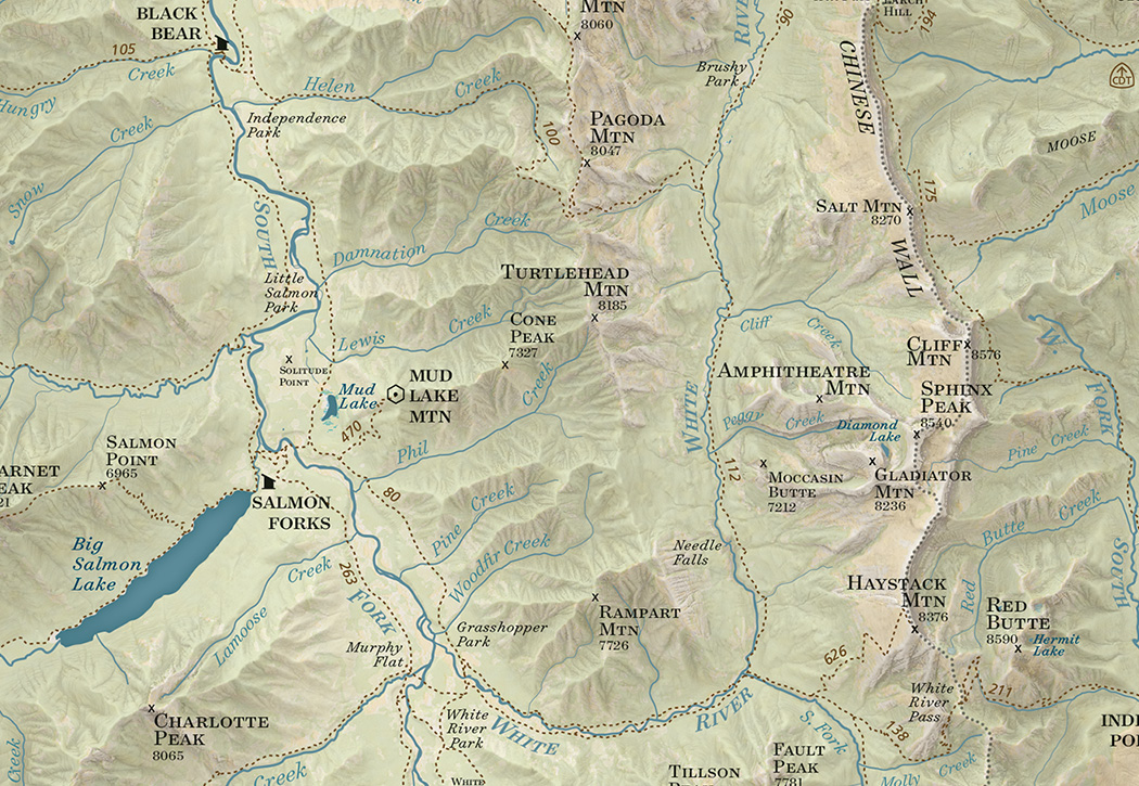
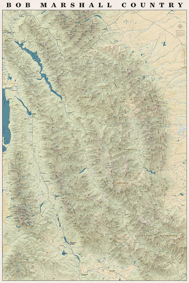
We have talked about (and received requests for) a map with the whole Bob Marshall Wilderness Complex since 2011 when we printed our first map. This spring the concept for that map finally started to take shape. We knew we wanted it to be totally functional so you could use it to daydream about new trips or reminisce about trips passed. We also wanted it to be an art piece- something that would look good in a frame on someone’s wall.
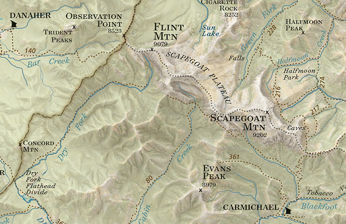
On the map you will find all the trails, cabins, trailheads, and ranger stations plus all the peaks, streams, rivers and geographic features that are on our other maps all overlaid on an updated terrain shading.
We are really pleased with how the map turned out and we had a lot of fun making it!
It also turns out when you put the entire Bob Marshall on one rectangular sheet of paper you end up with the entire Mission Range and Rattlesnake Wilderness on the page as well!
The whole map!
Every spring since 2011 it has been our goal to have a map finished and printed and on its way to customers by April. Our track record hasn’t been very good though- we’ve printed in June, July and last year in September. This year we really buckled down and we went to press the last week in March and it feels so good to be writing this new map announcement before the high country trails have even started to dry out and folks are still planning summer adventures.
The South Half of the Selway Bitterroot surprised us with how remote it feels and how varied the terrain is. From the highest peaks in the Bitterroot Range to sandy beaches on the Selway River there is a little of everything. As the crow flies a lot of the terrain looks like it isn’t too far from the nearest road- but when that road is the Magruder corridor road, or even Highway 12 a nearby by road doesn’t necessarily mean close proximity to civilization. Highway 12 might be one of the few federal highways in the lower 48 where you can drive over 100 miles without cell service!
Below are some pictures of our favorite places from this map. You can order it now from our website or pick one up at your favorite outdoor retailer in western Montana.
Watchtower Creek was one of our favorite hikes of the whole summer- awesome scenery, TONS of huckleberries and a good trail
The Montana/Idaho divide trail follows the state line north and south of Nez Perce pass through some beautiful meadows and ridges
Piper relaxing after a swim at Glen Lake- a great hike for kids with spectacular views
Green Mountain Lookout has views into the Selway Bitterroot and Frank Church in all directions
Some meadows just off the Magruder Road near Poet Creek. This is a section of the old Nez Perce Indian Trail
The view toward the Bitterroots from Spot Mountain Lookout. It’s five thousand feet in about six miles from the road to Paradise up to this lookout and you can see wilderness in every direction from the top.
There are countless steep ridges above the Selway River, this is the view from the ridge above Paradise Guard station near the put-in for the wilderness float section of the Selway River
Piper and Jamie on the ridge above Paradise
Copper Butte near Indian Hill high above the Selway River. Grassy ridges for days
Near Buck Peak- we spent five days backpacking in this area and didn’t see a single other person
Fall camping at Buck Lake- we tend to avoid camping on lakes during the summer because of Mosquitos but in late September they are beautiful!
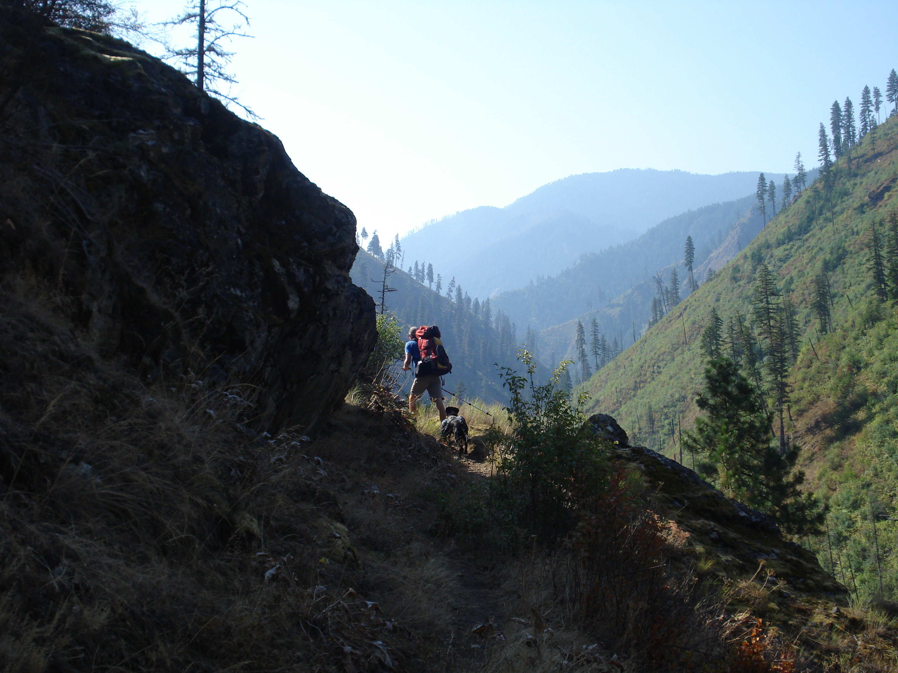
We spent September and October wrapping up our field season in the South Half of the Selway Bitterroot Wilderness. This is some beautiful, rugged and remote country! We got a little tired of the LONG drive from Missoula to get back to some of those trailheads (some took over seven hours to get to!) but we had a beautiful stretch of cooler weather which was much appreciated after a hot dusty summer.
Sunrise over the Bitterroots from the Windy Saddle areaHome away from home, you never know what toys you might need
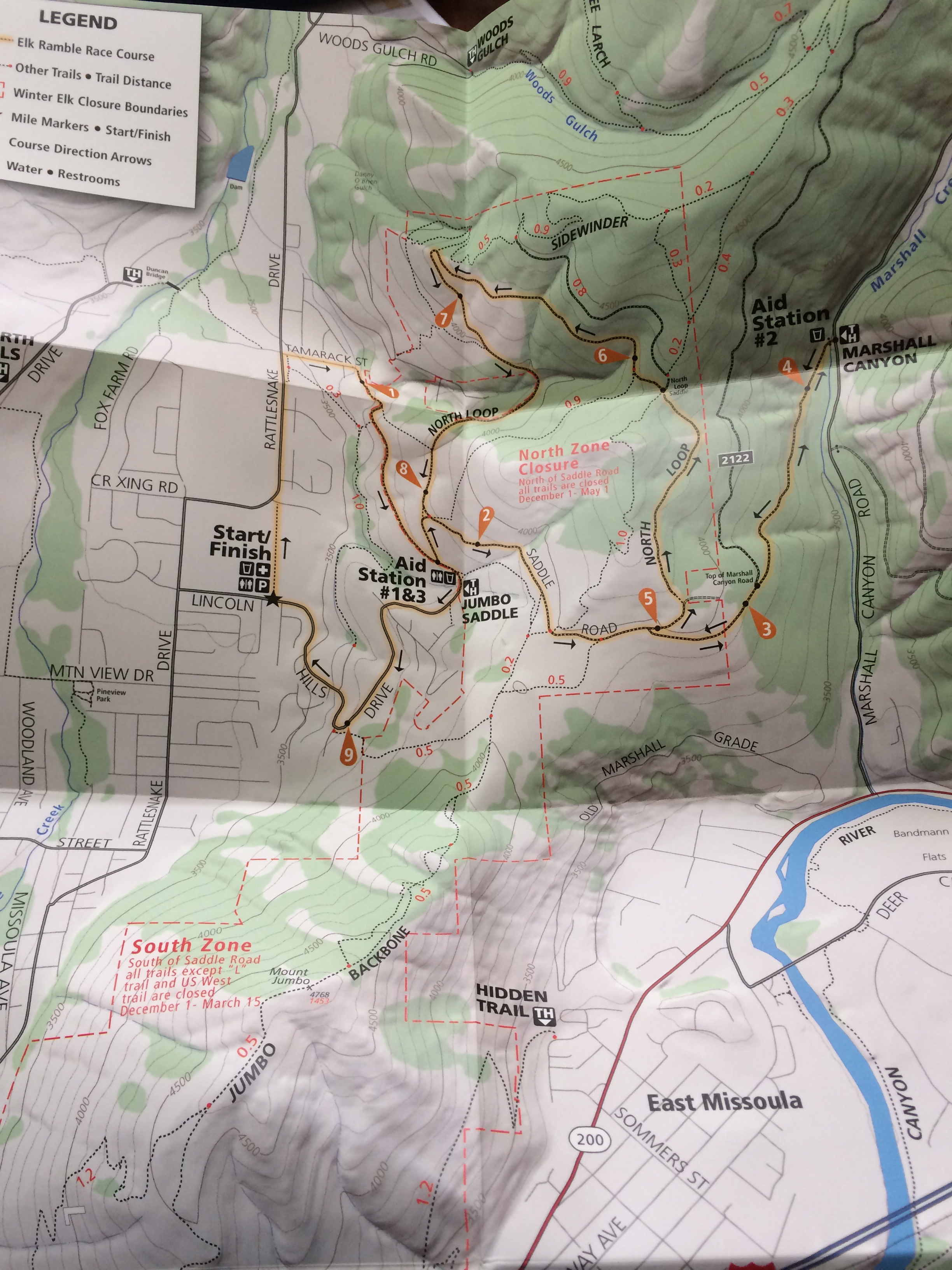
We got to catch up with the folks from the Selway Bitterroot Frank Church Foundation at the Telluride Mountain Film festival. Beautiful inspiring films and good company! We partnered with Run Wild Missoula to make a map of the Elk Ramble 15k trail race that took place on November 8th. Each participant received a map of the Mt Jumbo area with the race course highlighted printed on waterproof plastic. It was a super fun project and a really fun race!
Elk Ramble Map- crossing our fingers that this race can happen again!
We are deep into work on our next trail map- the South Half of the Selway Bitterroot Wilderness which we hope to print by next spring. It is always fun to re-live our summer on the trails as we comb through all the data.
“A wilderness, in contrast with those areas where man and his own works dominate the landscape, is hereby recognized as an area where the earth and its community of life are untrammeled by man, where man himself is a visitor who does not remain.” -The definition of Wilderness as stated in the 1964 Wilderness Act
I’ve spent most of the last two weeks visiting family and friends in the Northeast. Explaining what I do tends to be a little more involved in the Northeast because most people don’t have as thorough an understanding of federal land management as they do in the Rocky Mountain West. When I say I make maps of Wilderness areas I usually have to explain how a Wilderness area (capital “W”) is different than a National Park and usually contained within National Forest. The scale can be hard for people to wrap their heads around- some of the areas we are making maps of in Montana are bigger than the smaller New England states!
My explanation usually goes something like this: Wilderness is land within other public land that is set aside to remain “untrammeled.” The use of mechanized vehicles including bicycles is forbidden and the trails and infrastructure are maintained with traditional hand tools. In Montana most Wilderness areas are within National Forest Land and managed by the National Forests but they can also be managed by other agencies. Portions of many National Parks are managed as Wilderness but Wilderness areas are not managed like National Parks.
This week is the 50th anniversary of the Wilderness Act and all summer long events and articles have celebrated the anniversary. We are big proponents of any type of designation that protects wild places but our biggest loves are the huge Wilderness areas in western Montana. We are celebrating the anniversary of the Wilderness Act and the release of our newest map by offering 20% off all of our maps for this week only. So stock up!
We are so excited to announce the release of our fifth map- The North Half of the Selway-Bitterroot Wilderness! This map straddles the Montana-Idaho border and covers well over half of the Selway Bitterroot Wilderness. This is a spectacular area and we had some amazing experiences while we were out gathering data for this map. Grab a copy and head out there!
Included on the map:
Highway 12 from Lolo, Montana to Lowell, Idaho
Highway 93 from Lolo, Montana to the Lost Horse Road
The Bitterroot Range from Lolo Peak South to the Twin Lakes Trailhead and the Lost Horse area
Bitterroot Canyons between Hamilton and Lolo Including Blodgett and Kootenai Creeks
The Selway Road from Highway 12 in Lowell to Race Creek Trailhead
The Selway River from the Confluence with the Clearwater upstream to Moose Creek
Moose Creek Ranger Station
Elk Summit area
Jerry Johnson, Stanley and Weir hot springs
Map SampleArea CoveredA hike down the Selway River trail #4 is not to be missed!
I had an inspiring conversation with Kevin at Rocky Mountain Map Gallery today about the Print vs Digital topic which has been on my mind a lot recently. It’s always fun to talk to someone who is as much, if not more of a map geek as I am. Our conversation followed several tangents but we kept arcing back to two main points.
1. Nothing can replace a print map
2. You don’t have to choose between print and digital, they should be used together
Some of the reasons we kept coming back to:
Planning. Especially when you are going somewhere you’ve never been before you can spread out maps on the table or (my personal preference) the floor and see the area you are planning to go in context. You notice how the mountain ranges and rivers fit together and how the trail network connects one valley to the next or how one trailhead is easily linked to another to create a more interesting loop.
Dreaming. People tell me all the time that they “love maps.” I do too. I think what they mean is that, like me, they can spend hours staring at a map noticing which peaks divide which drainages and which creeks form the headwaters for bigger rivers. You can’t get lost like that on a four inch (or twenty-four inch) screen. This blog post talks about scheming and dreaming to connect various trails that you might not have thought to connect before and the power of print to inspire new explorations of familiar places.
Maps tell stories. You can lay a map out on the table and it becomes an instant focal point of the conversation. You gather around it and trace your fingers along rivers and ridge lines and tell the story of your adventure. You can point out where you saw a bear or found a monster huckleberry patch or almost ran out of water. Zooming around google earth is fun but it isn’t the same.
Soul. A well-made print map is beautiful. Print is a much higher resolution than digital and misplaced labels or awkward line widths stick out much more when you can look at a map as a whole and not just a little piece at a time. It takes a lot of time and skill to fit data from all different sources together and make it look good. Cartographers spend hours agonizing over font sizes, label placement and color choices. In our case we spend weeks on the ground to GPS the trails as well. We know what the trail along a particular creek feels like underfoot. We know how the trail is just far enough from the creek that the creek’s name can be squeezed in between them on the map. We know the landscapes that our maps cover and we know our maps themselves intimately and I think it shows through in the final product.
Navigation. You can’t beat a GPS for ease of navigation. It is a wonderful thing to be able to look at a little screen and see exactly where you are. Especially for off trail navigation or for something like hunting where your focus might not be on your surroundings as you tromp through the woods it can be lifesaving to have a device to help navigate back to your camp.
That’s the thing: It’s not an either or choice. You don’t have to choose between a map and a GPS unit. They are both incredibly useful tools. Nothing beats a GPS for navigation or tracking. I use Strava and I love my GPS as much as the next person and I almost always have at least one GPS-enabled device with me when I’m running or hiking (and I frequently have two or three). But I would never leave my map behind- one of my favorite things is to unfold my map at the top of a peak and use it to pick out distant landmarks and understand the landscape around me and a GPS can’t do that.
“There are some good things to be said about walking. Not many, but some. Walking takes longer, for example, than any other known form of locomotion except crawling. Thus it stretches time and prolongs life. Life is already too short to waste on speed. I have a friend who’s always in a hurry; he never gets anywhere. Walking makes the world much bigger and thus more interesting. You have time to observe the details. The utopian technologists foresee a future for us in which distance is annihilated. … To be everywhere at once is to be nowhere forever, if you ask me.” –Edward Abbey
I spend a lot of time ruminating on this Edward Abbey quote when I’m on the trail. There’s something about the pace of walking that just feels “right.” My brain can easily keep up with processing the sights, sounds and smells around me when I’m not hurriedly trying to figure out where to put my feet or bike tire or ski.
In the age of the Go-pro walking at three miles and hour with fifty pounds on your back doesn’t seem very flashy, especially next to that video your friend posted of ripping down that crazy descent on a mountain bike. It’s humbling to spend an entire day putting one foot in front of the other and in the evening retrace my crooked path across the my current corner of the map but exhilarating to think I’ve made it that whole way under entirely my own power.
There is still a lot of snow up high but summer planning has begun and after an office-intensive spring I couldn’t be more excited to start walking again.
I can’t write an announcement about the Missions map without talking about our dear friend Kyra Jean Wiliams. Last spring when we first pulled the whole map together Kyra was probably the only person more excited about it than me. She was living in Saint Ignatius at the base of the Mission Range and spent much of her free time exploring the mountains out her back door. She called or stopped by almost every weekend to check on the progress of the map or to look at our draft to plan her weekend outing. As some of you may know Kyra passed away in a car accident last August. This map is dedicated to her and to the spirit of adventure and the willingness to forge her own path that she embodied.
Kyra and I went to college together in Maine and we both ended up in Missoula after we graduated. Kyra was one of those people I always wanted to see more of. She was so vibrant and such a kind and colorful spirit. So grounded and so at peace with who she was and what she knew to be important in life. Unlike most of my female friends we didn’t spend a lot of time talking about relationship drama or life in a broad metaphorical terms. We talked about business plans and ways to create fulfilling careers doing what we loved in a way that we could avoid burning out. We talked about our Bates peers who were living in bigger cities following more traditional paths and how we felt drawn to this mountain town where you can touch the wilderness with one hand and gourmet coffee with the other. We both fell in love with Missoula because the culture here encourages a certain kind of dreaming- about how life doesn’t have to be either a successful career climbing the ladder or full of adventure; it’s possible to have both at the same time. It was always such a comfort to talk with someone who came from the same background and could appreciate differences between Missoula and Bates from the same perspective as me. I miss her dearly and I continue to be inspired by her passion for living life to the fullest.
-Amelia
Kyra in her little home at the base of the Missions photo credit: Grant Haynes
The idea to make a map of the Missions started in the spring of 2012. We were wrapping up the final details on our maps of the North half of the Bob Marshall and the Rattlesnake. We were in the beginning stages of shopping for our first house. We had two big family vacations and a week-long river trip planned for the summer. We knew we wanted to tackle another big wilderness map but after two years of going full steam we needed to slow down a little. We decided on the Missions for several reasons: its proximity to Missoula, we could do almost all the hiking as day hikes and, after driving past the Missions several times a week for the two previous summers we wanted to stop and explore!
The hiking part of the Missions map went fairly smoothly- although we may not have said that at the time. We had some frustrating mornings trying to find trailheads and a few adventures trying to discern if we were on a “real” trail or not. But for the most part we hiked to a lot of beautiful lakes, found some choice car camping spots and we were able to be in town enough to buy a house and move into it.
Putting the map together was a different story. Like many small businesses in their first years of business we have experienced some growing pains in the last year. As the volume of work grows and we try to balance outside jobs with keeping our existing maps up to date something was bound to slip through the cracks. The Missions map, as many of you know, has been “almost done” since last April. The final touches on a map always take much longer than we think they will and so here we are in January finally making the announcement that the map is ready!
Publication timeline aside, we are so excited to get this map out into the world. The Mission Range is a spectacular place. It has a little of everything- from craggy peaks and alpine lakes to dark cedar forest to beautiful doug fir parks and some of the best huckleberry patches we have ever seen. And it’s all packed into one super-accessible skinny little range. Whether you are looking for a multi-day ski tour, a Sunday stroll to a lake with the kids or a big day of bagging peaks there’s something for everyone. As always itis available at retailers around western Montana and on our website.
Have you been using our South Half of the Bob Marshall map? We’re getting ready to print a second edition and we want to hear from you. Have you found any mistakes? We’re looking for anything from mis-named peaks or trails to spelling errors. Shoot us an email at info@cairncarto.com and let us know!